Free beta
Available now$0 / today
Get out there and explore.
- 3D maps, boundaries, and acreage
- The full terrain toolkit
- Device records and downloaded maps offline
- Exports and backups
Ranch Mapper · 3D field scouting
Outline a field. Explore the terrain and weather. Keep a record of what you find and what you do.
Free in beta / No credit card / In your browser
Down to your next move.
MEET RANCH MAPPER
Start with ground you know.
Come back with a record of the work.
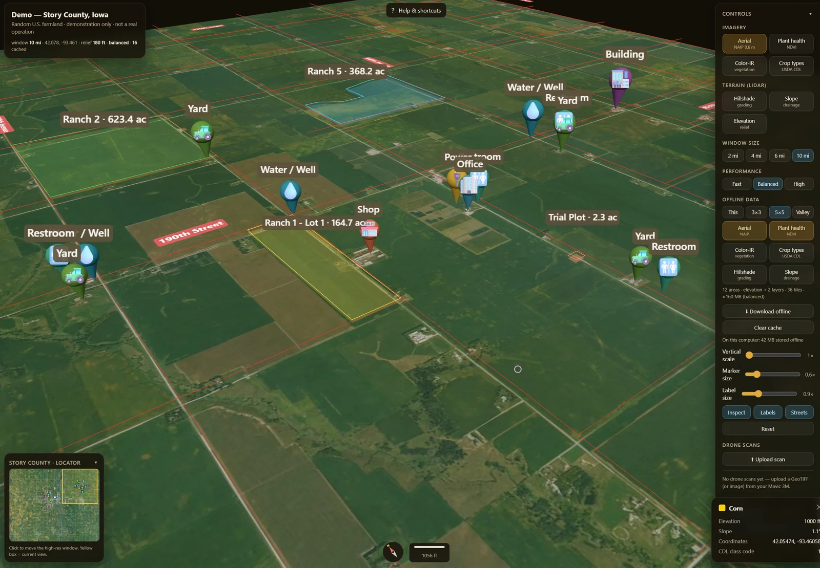
Actual app demo · Public aerial imagery + elevation · Relief exaggerated · Not a survey
Find your ground, draw a field, and see the acreage. Already have boundaries? Bring in your KML, KMZ, Shapefile, or GeoJSON.
Map acreage from your outline. Not a legal survey.
Explore slope and modeled low spots, then check the area forecast in Weather before heading out.
Terrain layers are scouting aids. Weather is a separate area forecast; the 3D animation illustrates it.
Open Work to enter fertilizer use, spray records, yield estimates, and harvest actuals. Add a ranch and field there if you need to log first and map later.
Check each fertilizer record’s sync status. Spray records stay on the device; include them and other device-only details in your backup.
Find modeled depressions and possible drainage paths from the terrain. Blue shows filled basins; cyan shows modeled flow paths. Use them to choose low spots to inspect.
Won't tell you. Terrain shape only. The acre-feet figure is a brim-full worst case — every bowl filled to the lip — a modeled storage volume, not observed flooding or a drainage design. It ignores soil soak-in, actual rainfall, and existing tile or drains, and reads a coarse grid, so narrow swales get missed.
Explore relative cold-air pooling from terrain shape: blue for lower pockets and orange for higher-ranked thermal belts. These are places to check, not measured temperatures or predicted frost.
Won't tell you. No temperature, no wind, no date, no forecast. Real wind mixes the air and can erase pooling entirely. Colors are ranked within this one field, so even fairly uniform ground still shows blue and orange. Relative risk to go scout, nothing more.
Hours of direct sun on each part of a field today, given the hills and ridges around it. Yellow sunniest, blue most shaded — good for the corner that's chronically cold and slow to dry.
Won't tell you. Terrain shadows only. No clouds, no fog, no trees, no buildings. Times are local solar time and colors are scaled to this one field, so “yellow” only means sunniest here. Read the hours.
Compare terrain-based drainage tendencies within a field. Red marks relatively shedding areas, blue marks collecting areas, and cyan traces modeled runoff paths. The map does not measure soil moisture or simulate an irrigation set.
Won't tell you. This is a terrain-layout aid, not an irrigation recommendation. No evapotranspiration, no soil type or infiltration rate, no weather, no crop stage. Sandy versus clay can flip what a zone means. Zones rank within one field and are never an absolute rate. Size and schedule real irrigation with your agronomist, your soil and ET data, and your meter.
Pick 25, 50, 100 feet or your own number and it draws the buffer in from every edge, leaves the plantable core green, and gives you the acres of each plus the percent you lose.
Won't tell you. You enter the distance — the tool does not decide the legal buffer. That comes off the chemical label, your county ag commissioner, and what's next door. It measures flat distance from the boundary you drew, ignores internal features like wells and ditches, and flags on screen when a very small setback on a large field gets approximate.
Percent grade across the field — green gentle, red about 15% and steeper — with the average, the steepest, and how much of the field sits over a working grade.
Won't tell you. These are absolute grades on a fixed scale, but still a field-scale read off a coarse public grid. It won't find a two-foot berm, and it is not an engineering design or a machine-safety determination.
See which direction each slope faces. Use the orientation as one clue when checking differences in exposure across the field.
Won't tell you. Direction off the terrain surface, nothing else — no sun, no season, no soil, no canopy.
Explore a balanced cut-and-fill estimate in cubic yards from the loaded elevation surface.
Won't tell you. A terrain-model estimate, not an engineering design. No shrink or swell, no haul modeling, and a balanced plane is not a designed grade. Never a pay quantity.
Pin two single-band drone scans of the same field — a DSM pair or an NDVI pair — and get a per-cell change overlay: cut and fill in cubic yards from elevation, higher and lower NDVI acreage. Ranch Mapper also displays imported GeoTIFF scans (RGB, NDVI, elevation) draped on the 3D terrain.
Won't tell you. The tool compares maps; it does not make them, align them, or calibrate them. Photogrammetry surfaces include the canopy, so a cut/fill figure stacks both flights' errors. NDVI here is relative, not calibrated — where to walk first, not a diagnosis and not a prescription.
Reading the map: Detail depends on the source and the loaded terrain window. Nearby-detail settings control loading effort. Vertical scale changes the display: 1× shows true proportions; higher values exaggerate relief. Read the numeric slope and acreage values rather than judging them from the 3D view.
Try a tool on a field you know →
Not sure what you're looking at? Read the field guides → · Every one of these panels repeats its limits inside the app, where you're actually making the decision.
ROOM TO GROW
Ranch Mapper is free during beta.
Monthly plans are coming.
$0 / today
Get out there and explore.
$19 / month
For one person, across the operation.
$49 / month
One workspace. Five people.
Prices are USD and billed monthly when available. Checkout is not open. Applicable taxes will appear before purchase. Monthly subscriptions renew until canceled. Exports, backups, and access to saved local records remain available after paid access ends.
A FEW GOOD QUESTIONS
Public data. Your records.
No mystery in between.
LET’S MAKE IT USEFUL
A question, a rough edge, or an idea from the field.
We’d like to hear it.